Esri is the recognized global market leader in geographic information system (GIS) software, location intelligence, and mapping. Founded in 1969 in the United States, Esri currently has offices around the world with more than 5,000 employees.
Esri offers ArcGIS, a geographic information platform for both government customers and commercial organizations across virtually every industry - wherever digital maps, digital business transformation, digital twins, and geographic analysis are needed.
ArcGIS is used by more than 350,000 organizations worldwide, including 90% of the Fortune 100 Companies List, most national governments, 30,000 cities and local governments of 12,000 universities.
ArcGIS Users Worldwide

Data+ International has been operating in the market since 1992 and is the official distributor of Esri in the CIS countries: Armenia, Azerbaijan, Kazakhstan, Kyrgyzstan, Tajikistan, Turkmenistan, and Uzbekistan.
In the CIS, Esri's ArcGIS software is used by more than 3,600 organizations in practically all industries.
We provide Esri software licenses, train specialists in ArcGIS technologies on the basis of our own Training Center, provide technical support for Esri software, consult on the use of GIS, and assist our Partners in Esri software implementation projects.
010017, Republic of Kazakhstan, Astana
Mangilik El Avenue, Astana Hub Technopark
Pavilion C 3.5, office 208

Data+ International Clients in Uzbekistan


Industries
ArcGIS enables the use of geographic context for design challenges in the infrastructure planning, design, construction, and operation. Using GIS in the master planning phase allows you to arrange a unified information space for project designers; select the best sites for development through geospatial analysis; evaluate how the project fits into existing neighborhoods, transportation infrastructure, utilities, and landscape; provide a GIS portal with projects and a catalog of geodata; collect field data for display in the project; and ensure an easy access to the deliverables for stakeholders through web-based GIS technologies in the 2D and 3D environments.
ArcGIS is a comprehensive geographic information system (GIS) used by operating companies and the utility sector to manage and analyze spatial data, improve operations, and support decision making. ArcGIS provides a geospatial data model to create a digital representation of networks, scale them to any size, and simplify the process of connecting new customers. An engineering network is a special data type in ArcGIS designed for modeling engineering systems such as electrical power, gas, or water supply, storm drainage, and sewage. This data type allows users to create and edit objects that model the equipment in use, trace the network, and analyze its performance. Off-the-shelf ArcGIS solutions, such as ArcGIS Water Distribution Data Management, can be applied (after minimal customization) to map water supply facilities, edit data, view maps in the field and office, and generate asset reports. An engineering network allows you to display your assets in a variety of ways: as thematic maps or a schematic representation of the network. ArcGIS enables users to analyze various events, such as equipment outages, as well as planned maintenance schedules.
Maximize all opportunities of the corporate GIS by providing centralized access to mapping and spatial analytics to all departments of the company. ArcGIS has proven its effectiveness in conducting cost-intensive oil and gas exploration and drilling operations, managing production assets, optimizing the location of infrastructure facilities and supporting oil company operations, as well as solving sophisticated aspects of maintaining corporate databases on property rights, leases and other property relations. ArcGIS provides access to the most complete, consistent and up-to-date data, allowing to optimize daily activities such as surveys, geophysical exploration, asset inspection, and operational control. ArcGIS brings a new level of quality in terms of business analysis and decision making by combining corporate information systems with the information on the spatial location of assets.
ArcGIS assists mining and exploration companies with a wide range of practical tasks in exploration, mining, mineral transportation, development of geologic maps and atlases, reserve estimation and reporting, and also environmental protection and reclamation planning. Analyze exploration data in a spatial framework to perform primary data analysis. Use your GIS to plan and conduct exploration activities. Employ the power of the GIS to support land surveying, automate land and property management, and provide a single point of access to up-to-date spatial data for all company departments. Using GIS tools, you can monitor production indicators and enterprise assets in real time. The ability to integrate data and indicators from different enterprise information systems allows you to significantly increase operational awareness and the quality of management decisions.
ArcGIS offers to launch a geographical information system both at the level of a farm and at the level of the Ministry of Agriculture as has been confirmed by its implementations in the CIS and worldwide. The first task that is solved at the stage of GIS implementation is to create a unified database of all land assets. Next, ArcGIS allows to significantly reduce the scope of development and establish an effective system of remote monitoring of crops, while applying satellite images and images from UAVs to assess the state of vegetation. Mobile GIS applications help agronomists to orient themselves on the terrain, get all reference data about the field from the internal geodatabase, and further conduct inspections and record photos and characteristics of crops, including those affected by pests. Precision farming relies on geospatial analysis tools, such as building productivity maps and taking into account terrain characteristics on the basis of ArcGIS spatial analysis tools. The results of such processing can be uploaded in the form of data for differentiated fertilizer application techniques. ArcGIS users can leverage not only their own data, but also connect the extensive library of updated Esri data. starting from surface topography and to satellite imagery, moisture and moisture accumulation charts, vector data, and so much more. As a result, ArcGIS allows you to organize effective management of agricultural lands and exercise operational control over the quality of work and consumption of inventory, it helps in making management decisions and serves as a basis for predicting yields. Also, government agencies can create open atlases of agricultural lands and interactive investment maps.
We offer many functional features within a GIS for the transportation industry, including planning, analysis, road asset management, and monitoring and data collection through mobile applications. ArcGIS provides a road network model that allows you to calculate trip timing, determine service areas, calculate distance matrices, and optimize depot placement. Esri products support creation, storage and analysis of linear coordinates (distance from a point of reference), having options for converting linear coordinates to geographic coordinates and vice versa. ArcGIS includes tools for integrating public transportation schedules (as GTFS) into a road network model. The road network model can also contain information about current and previous traffic. Our products can be used both for planning new transportation infrastructure based on demographics and other geographic factors, and for monitoring the condition of existing facilities. In addition to the ArcGIS platform, which is easily adaptable to the user's needs, there is also a set of specialized solutions: ArcGIS for Roads and Highways, ArcGIS Aviation Airports, ArcGIS Aviation Charting.
State, regional and municipal authorities make daily decisions directly affecting the interests of citizens in the territories within their area of responsibility - state, region, city, municipality - on various issues, ranging from implementing territorial development plans to managing property assets. Every year geographic information systems are more and more often engaged in decision-making, as they allow to keep digital twins of objects and analyze spatial data. Examples of using GIS include environmental quality control, management of public utilities, or interaction with the population in terms of territory management.
Provide students, teachers, and classrooms with the state-of-the-art software for geographic science and geoinformatics education. Get license packages as part of the higher education support program. As a result, you'll have all GIS tools, geodata services, and access to Esri's library of educational materials to provide cutting-edge teaching supported by hands-on resources. The licenses can also be used to deploy the university's educational geoportal, organize data collection within the framework of students' field internships, and create interactive applications containing the results of research as well as thesis and term papers.
The geographic information platform offered by Esri is used by enterprises and national mapping and cadastral agencies in many countries, including Europe, Central Asia and Transcaucasia. GIS helps to collect and maintain cadasters in a centralized manner as well as provide open information through web portals. Solutions for cadastral data maintenance include a wide range of options: a cadastral engineer's workstation, a system for maintaining territory-related cadastral data from a municipality to the state level, and maintenance of on-duty cadastral plans for various entities and organizations. For each of the solutions ArcGIS offers optimal sets of tools that provide effective management of real estate objects. Many additional modules have been developed on the basis of ArcGIS to automate individual operations, for example, downloading cadastral plans and spatial analysis of the boundaries of land plots for lease.
Practical Applications of ArcGIS in Kazakhstan
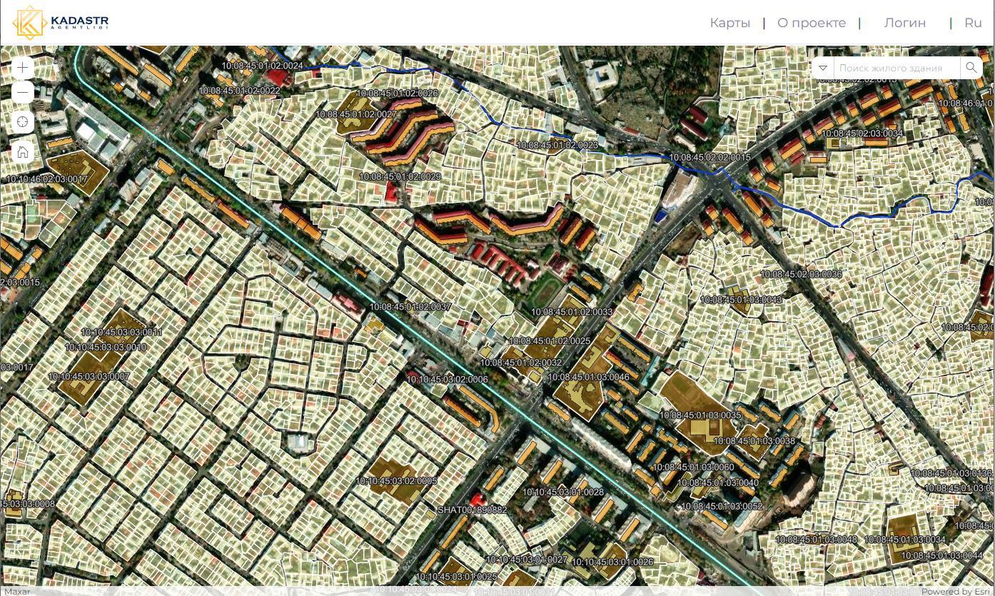
Public geoportal of the State Cadastre Agency of the Republic of Uzbekistan
The purpose of a geographic information system is to provide open data from the state register of rights to real estate government bodies and economic associations, individuals and other legal entities through National GIS of the Cadastre Agency.
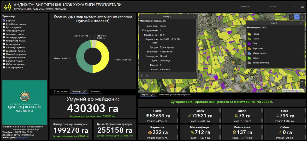
GIS of the Ministry of Agriculture of Uzbekistan
As part of a multi-year project to create a GIS for the needs of Ministry of Agriculture Digitalization Center agro-industry, a single distributed GIS was created with support for centralized field mapping, collection agrochemical indicators, field personnel management, updating field boundaries and control over land use agricultural purposes. This comprehensive system completely built on the ArcGIS platform, put into operation and is serviced by company employees. In 2023 the project was awarded the Special Achievement in GIS Award (SAG).
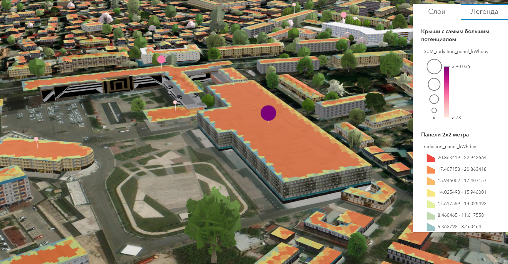
Digital Twin of Tashkent City
Toshkentboshplan LITI has implemented geoinformation system for urban planning. During the project it was possible to achieve a reduction in the time it takes to create a baseline (situational map), from 6-8 months to 2 months, the volumes of the city were visualized, rules for the development of the city were created, completed assessment study of citywide installation capacity of solar energy panels based on available spatial data, an automated system for obtaining permits has been created for construction based on a GIS map. In 2023 the project was awarded the Special Achievement in GIS Award (SAG).
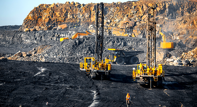
Corporate GIS of Almalyk Mining and Metallurgical plant
During the implementation of the project, a topographic data model and a thematic data model were developed, a GIS infrastructure was created to ensure the creation, storage, maintenance of spatial data, providing them to various categories of users, the activities of the surveying department were automated in terms of working with spatial data by land plots.

Esri Higher Education Program
Esri's university programs have been operating for more than 30 years around the globe and are designed to prepare top-notch professionals whose professional activities will be related to geographic information systems.
Nowadays, universities participating in the program can receive free ArcGIS training kits, exchange study programs, train their teachers, participate in regional and international cooperation of universities and student programs, as well as represent their universities at international events.
ESRI, is willing to assist universities and institutes of Central Asia in their participation in the said activities.
The DEvision program has been established for students who speak English and are interested in improving their GIS knowledge. This program offers online modules for self-study.